MORE IN CATEGORY
ADVERTISEMENT
Residential Products Online content is now on probuilder.com! Same great products coverage, now all in one place!
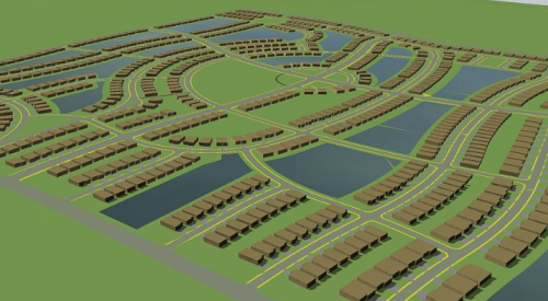
| Decision-makers in Ryland Homes’ Washington, D.C., division use a map-based tool to track land on a lot-by-lot basis. |
A phone call, a fax and a drive out to the site are the usual ways builders commonly track the progression of land development. Not so at Ryland Homes’ Washington, D.C., division, where a technology tool keeps the data on dirt flowing.
From the time a lot is cleared to the time paving is complete, phase checks are seamlessly passed from hand-held computers to the company’s mainframe, where a color-coded map of each site is generated.
“It is the graphical presentation and the ability to quickly interpret status that makes it is much easier than going through the paperwork on 75 lots and figuring out where they are,” division president Scott Gallivan says.
In addition, the hand-held data are quickly imported into the master time line (Gantt chart) for each project, so scheduling trouble is spotted and averted well before deadlines are jeopardized.
“If I know that my curb and gutter has to be in and it is not, it shows up immediately,” says Gallivan. “It is one of a series of checks and balances that we use to stay on top of what is going on in the field, especially when you are spread out as far as we are.”
The program, developed and implemented by Tampa, Fla.-based MediaLab, helps Gallivan’s team track 1,000 lots in 20 communities in Virginia and Maryland.
For more information, go to www.medialabonline.com.