MORE IN CATEGORY
ADVERTISEMENT
Residential Products Online content is now on probuilder.com! Same great products coverage, now all in one place!
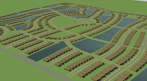
| The connectivity index for these three land plans ranges from 1.2 to 1.5. The index is calculated by dividing the number of street links by the number of intersections and cul-de-sac turnarounds.
|
Don’t be surprised if the next time you show a land plan to local officials, they start counting streets and intersections and putting those numbers into a calculator. In all likelihood, the number crunching will yield an index of street connectivity. In many instances, the officials will gauge whether the figure satisfies local requirements.
Town planner Tom Kopf with Downing, Thorpe & James in Boulder, Colo., says the term street connectivity index might not yet have meaning to builders and developers, but it’s something to watch as it catches on in many communities via planning professionals.
The index grew out of the New Urbanist movement, which embraces street connections to facilitate foot traffic and reduce pressure on arterial streets by offering myriad alternatives to vehicles. Now the index is being written into many local planning ordinances. In Cary, N.C., the number of street links divided by the number of street nodes and intersections must be 1.2 or more.
For perspective, sections of Manhattan’s street grid have a connectivity index of 1.7, while a custom home subdivision with many cul-de-sacs and few access points to arterial streets would have an index of about 1.1.