MORE IN CATEGORY
ADVERTISEMENT
Residential Products Online content is now on probuilder.com! Same great products coverage, now all in one place!
| Views and open space in a clustered neighborhood at The Canyons.
|
Last June, Douglas County commissioners unanimously approved The Canyons, a 5,576-acre community north of Castle Rock, Colo. Thus ended a decade of controversy and a battle by principal developer Lee Alpert.
The site had been owned by Happy Canyon Partners, a group of developers and investors led by Alpert, since 1984. Left undeveloped for years, the land was being used by neighboring residents for camping, horseback riding and other recreational activities. It was one of the last untouched stretches of Interstate 25 between Castle Rock and the greater Denver area, and neighbors weren’t pleased when Happy Canyon Partners submitted a development proposal in 1990.
The original plan, an annexation to Castle Rock that called for 16,000 homes and 9 million square feet of commercial space, was rejected. The developers scaled back the plan and resubmitted it in 1997 as a free-standing community of 12,000 homes and 8 million square feet of commercial space. Again, county planners rejected it, saying it was too much development for the area. Douglas County had grown at a record pace throughout the 1990s, and anti-growth sentiment was rampant.
Alpert says another problem was that the early plans were not discussed with residents. "You had people who had been living around this property for 20 years and had enjoyed it as open space," he says. "They just didn’t want anything to occur [on the site]." In addition, the county had issued a report, the High Plateau Study, recommending that the land be preserved as open space to provide a buffer between metropolitan Denver and Castle Rock.
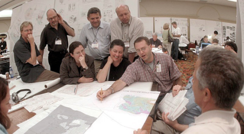
After the second proposal was shot down, Alpert took the lead in an effort to get The Canyons approved. He was familiar with Newport Coast, Calif., a 9,000-acre community that he thought had many similarities to The Canyons. One of the key designers of the Newport Coast land plan was RNM Architects & Planners in Newport Beach, Calif. Alpert invited RNM principal Steve McCormick to Denver and gave him a copy of the Douglas County master plan (adopted in 1992) and the High Plateau Study. McCormick spent several days traveling around the area and taking hundreds of photos.
McCormick identified open space and separation between identifiable communities as the most critical issues. He recommended a 500-acre preserve along I-25 to maintain a buffer between metro Denver and Castle Rock. The preserve was to be restored as a native Colorado Mesa grassland habitat. "Also, because the views were important, the development pods were located behind knolls and tucked into the landform so they would have the least amount of visibility from I-25," he says. The community would be organized into villages, each having an identifiable character with a focal point, such as an equestrian center.
Alpert’s next step was to work with the county "and all the homeowners who had previously been in adamant opposition. We met with the neighborhood groups to apologize for not getting their input previously and to try to engage them in a conversation." From June 1997 until June 2000, Alpert and his team made the rounds of 20 homeowners associations.
"We took a flogging at the first couple of meetings from each group," he says. "We finally started engaging people when they saw that an owner, as opposed to just a hired gun, was coming out and humbling himself, and really listening."
During that three-year period, Alpert estimates, he attended 200 meetings. A citizens advisory committee (CAC) was formed to represent homeowners living in the immediate area. "We invited stringent opponents, people who were neutral and people who wanted to engage in talk about possible solutions," Alpert says. For about a year, the CAC held in-depth discussions on specific issues such as buffers along the highway, open space, wildlife habitats, schools, traffic, pedestrian trails and bridle paths. Using the county’s master plan as a guide, the CAC hammered out a new plan for The Canyons.
Alpert’s team made presentations to the community at large based on the CAC’s recommendations, and little by little he gained support. "It needed to be grass roots, and it needed to be safe for the public officials to start feeling better about the plan. Out of the 20 homeowners associations [that] had previously been opposed, I think we ended up with 15 or 16 either in favor of [the plan] or at least not opposed to it." He even got letters of support from a third of the homeowners who lived adjacent to the property.
Jackie Thompson, who was assistant planning director for Douglas County at the time (she’s now an independent consultant), supported the project and helped shape the site plan. "She was very, very good," Alpert says. "We walked almost every inch of that site and carved in development pods to fit in as best they could with the neighbors."
The revised plan that Alpert submitted to planning officials in 1999 was a radical departure from the first two. The number of homes was reduced to 2,676, the commercial component was eliminated, and three golf courses were added. But once again, the county voted against the project, reiterating homeowner complaints about traffic and the lack of a buffer from metro Denver.
Further modifications were made. One of the golf courses was dropped, the number of homes shrank to 2,501, and residences were moved behind ridges to preserve views. More than 3,300 acres were designated as open space, including several parks and 60 miles of pedestrian and equestrian trails for public use. The developer made other concessions, such as creating a water district, donating land for three schools and contributing funds to the county school district for the cost of additional students. This plan got the green light, and Alpert signed an agreement promising residents he would not deviate from it.
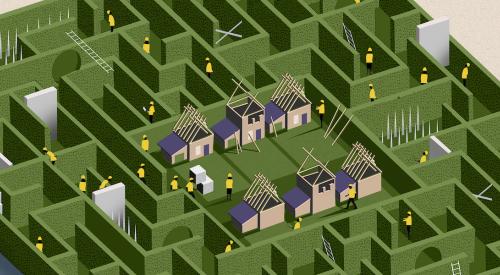
McCormick says clustering was the key to making The Canyons acceptable to planning authorities and residents. Higher densities are located toward the existing, more urban areas of Castle Rock to the south, while lower densities and open space are to the north.
"To comply with the county’s master plan we had to have densities of one unit per 21/2 acres," he says. "But instead of having all 21/2-acre lots, we clustered the units into smaller pods that would have smaller lots at higher densities on a net basis — yet on a gross basis, quite a bit of open space was preserved." Depending on their location within the community, lots are as small as 5,000 square feet and as large as 35 acres. "There were some adjacent 35-acre ranches surrounding the property, so we proposed compatible 35-acre lots adjacent to those areas," McCormick says. To accommodate increasing demand in Douglas County for half-acre and 1-acre lots, McCormick included those in the plan as well.
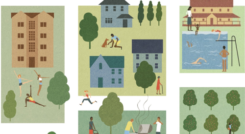
During the final public hearing before the Board of County Commissioners, Thompson cited a study showing that the types of homes planned at The Canyons were in short supply in Douglas County. She illustrated the advantages of cluster development by showing photos of her own neighborhood in Boulder County, where houses on 1/3-acre lots are close together but surrounded by trails, parks and open space. At first, the public "latched onto small lots as the last thing that they could fight this with," Thompson says. "They said, ‘These are 1/2-acre lots — that’s not rural.’ I showed them that clustered lots really can have a rural feel, and I think they came to understand that it was a better way of using the land." While The Canyons still has hard-core opponents, even they concede the plan is a good one, she says.
Although the plan calls for some townhouses, most of the homes will be detached and range from $400,000-plus into the millions, says Alpert. As this article went to press, plans for the first golf course were being developed. Home sales had not started. "We’re working with the utility companies and setting up metropolitan districts," he says. "We want to do our golf course deal first; that’s going to be the thing that will instigate the development."
Rewriting the Rules of Suburbia:
The Canyons, Douglas County, Colo.
Also See:
Rewriting the Rules of Suburbia
City Moves UGB to Allow New Development
Integrating Old and New
Charrette Builds Consensus for TND
Rewriting the Rules of Atlanta's Vast Suburbia
Rewriting Land-Use Rules in Lancaster County: Balancing Framing and Growth